Coalisland Camino – Our Way:
Having completed several Caminos across the Galician region of northern Spain, members of the Friends2Talk mental health group were inspired to bring the spirit of El Camino de Santiago closer to home.
Recognising the transformative impact such a pilgrimage can have on emotional and mental wellbeing, they envisioned the creation of a local Camino rooted in the landscape, culture, and history of Coalisland and its surrounding areas.
While the terrain of Mid-Ulster does not mirror the dramatic hills, valleys, and sweeping plains of Galicia, it offers its own distinct beauty, gentle lowlands, historic canals and rivers, and the vast, tranquil presence of Lough Neagh. In this rich natural and cultural setting, the Coalisland Camino was born.
Designed as a fairly level walking route with a few modest inclines towards the final kilometres, this path invites participants to journey not only through the physical landscape but also through centuries of Christian and local heritage.
The Coalisland Camino is not intended as a competitive event. There are no time targets, no prizes for speed, and no pressure to perform. Rather, it is a space for reflection, connection, and inner wellbeing.
Pilgrims are encouraged to move at their own pace, pausing wherever they find moments of serenity, spirituality, or emotional resonance. These pauses, whether at a quiet bend in the canal, a churchyard steeped in history, or a tranquil spot overlooking Lough Neagh, are as vital as the steps themselves.
The walk is designed to promote mental wellbeing, offering individuals time and space to explore their emotions, reflect on life, meditate, and reconnect with their inner self. It is a journey of self-discovery and healing, in the company of nature and community. Pilgrims are invited to embrace the communal spirit of the Camino by exchanging warm greetings with fellow travellers.
Whether it be “Camino Mhaith”, “Happy Camino”, or “Buen Camino”, these simple gestures reflect the camaraderie and shared intention that underpin the walk.
Above all, the Coalisland Camino encourages each person to be yourself, find yourself, and enjoy yourself. Go n-éirí an bóthar leat.
We are now affiliated with the Camino Society Ireland, and are part of the official ‘Celtic Camino’
The Route
MAP AND GUIDE
The Coalisland Camino is a 26.4-kilometre circular walking route that offers a unique opportunity to explore the cultural, historical, and environmental richness of Coalisland and its surrounding region in East Tyrone. Designed to be accessible for walkers of varying abilities, most of the trail, approximately the first 19 kilometres, consists of level terrain, with a series of gentle hills in the final 7-kilometre segment. The Camino begins and ends at the Community Hub, located at St. Patrick’s Hall, an institution that has served as a focal point for social and cultural activity in the town since its establishment in 1888. This venue has long embodied the communal spirit and resilience of Coalisland, hosting numerous events that celebrate local identity and shared heritage.
Departing from the Community Hub, the Camino follows the historic Coalisland Canal for approximately seven kilometres. This stretch offers an immersive experience of the region’s industrial and navigational history. The route then proceeds across Reenaderry Road at the High Bridge and transitions into the low-lying, scenic expanse of Derrytresk and Derryloughan. These areas are not only visually striking but also ecologically significant, containing vital habitats for the endangered Curlew, Irish Hare, and Native Irish Honeybee. The trail continues past Port Naomh, a site of spiritual and cultural importance, and moves toward the Maghery Ferry, an area with deep historical resonance in local memory.
As walkers follow the Ferry Road, they encounter the Holy River, a landmark embedded in local folklore. According to tradition, this river was blessed by St. Brigid, imbuing its waters with reputed healing qualities. A short distance beyond, the route arrives at the Washingbay Centre, where visitors may pause for refreshments and access the Holy River. From there, the trail ascends to Fuith na nGall on Cloghog Hill, providing panoramic views across Lough Neagh, Europe’s largest freshwater lake, and leading towards St. Patrick’s Roman Catholic Church in Clonoe.
Continuing through the rural landscape, the Camino intersects with several roads, including Mountjoy Road and Moor Road, following Lisnastrane Road to the Stewartstown Road, following the Mousetown Road to the Mullaghmoyle Road. At this junction, you will be looking across a valley and hill, behind which is the Crannóg on Roughan Lough (1.2km), and to your right, towards Stewartstown (3km), is the famous Creeve Lough Crannóg from where Hugh O’Neill departed on the epic Flight of the Earls in 1607, a pivotal moment in Irish history.
The final leg of the Camino leads to Patterson’s Corner, now home to the Four Corners Bar, before turning back towards Coalisland. En route, walkers obtain their penultimate stamp at St. Mary and St. Joseph’s Roman Catholic Church, a site that further enriches the spiritual narrative of the journey, before completing the Coalisland Camino at the Community Hub, St. Patrick’s Hall.
The Coalisland Camino is more than a physical path; it is an interpretive journey through time and place. Each landmark along the route contributes to a deeper understanding of the region’s layered identity, its environmental treasures, spiritual traditions, and historical milestones. For participants, the Coalisland Camino Passport and commemorative stamps serve as meaningful souvenirs, encapsulating the essence of a walk that is reflective, educational, and profoundly rooted in local heritage.
Experience our History
Points of Interest

ST. PATRICK’S HALL

CORNMILL

COALISLAND CANAL

MAC’S LOCK

ST MARY & JOSEPH RC

FERRY BRIDGE

WASHINGBAY CENTRE

LOUGH NEAGH

CLONOE CHAPEL
Creating Memories
PASSPORT & STAMPS
Walkers of the Coalisland Camino can enhance their journey with an official Camino Passport, perfect for collecting beautifully designed stamps at key points along the 26.4km route. Each stamp has been specially created by local artists, offering a unique memento of your experience and a connection to the places and people that shape this walk.
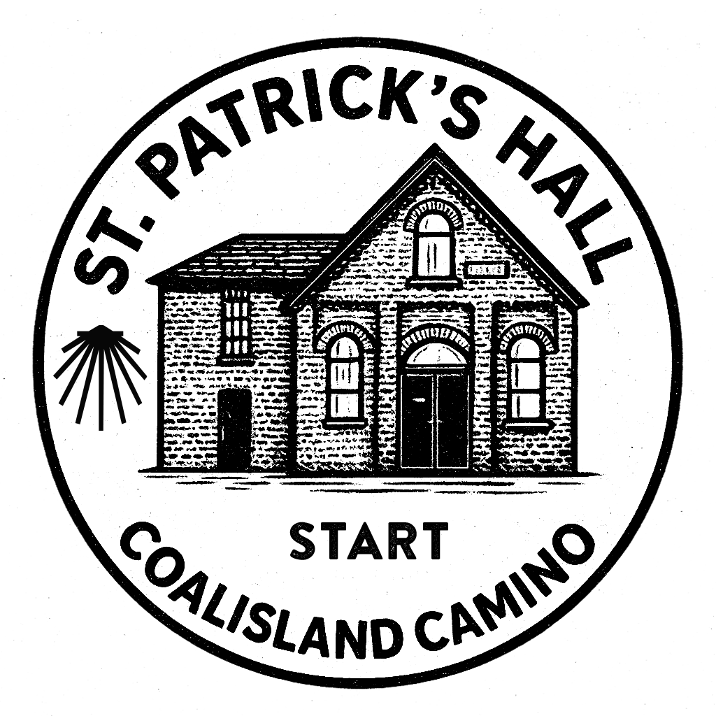
St. Patrick's Hall
Constructed in 1888, St. Patrick’s Hall has long served as a central hub for the political, cultural, and communal life of Coalisland, County Tyrone.
READ MORE
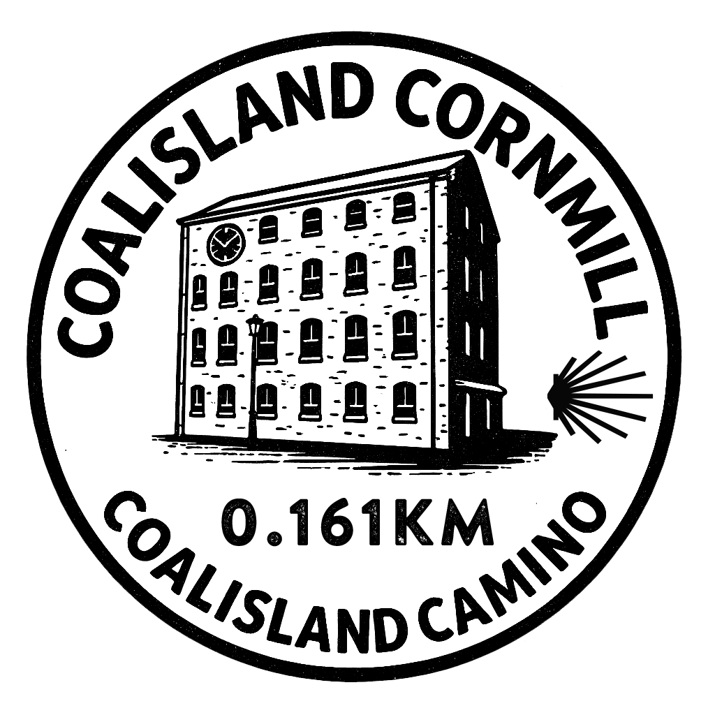
Coalisland Cornmill
The Coalisland Cornmill, also known as Stewart’s Mill, is a significant industrial and architectural landmark that has stood at the heart of Coalisland for over a century.
READ MORE
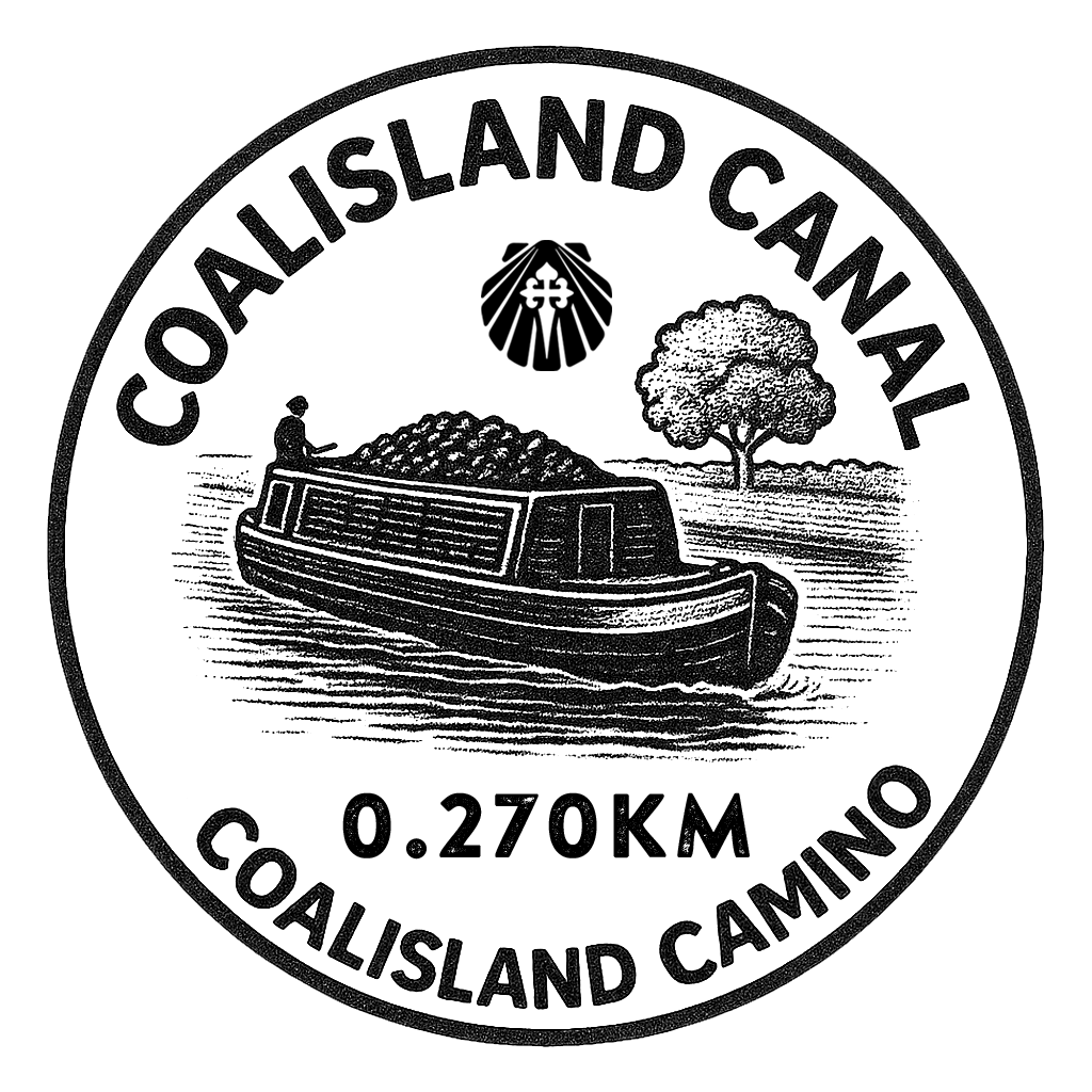
Coalisland Canal
The town of Coalisland developed around the terminus of the Coalisland Canal, which was originally intended to transport coal from the Tyrone coalfields to Dublin.
READ MORE
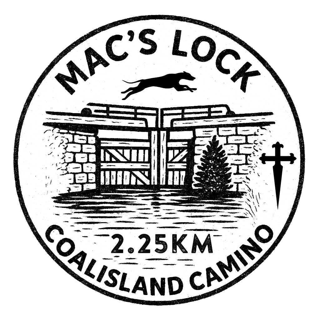
Mac's Lock
Mac’s Lock is one of the most iconic points along the Coalisland Canal.
READ MORE
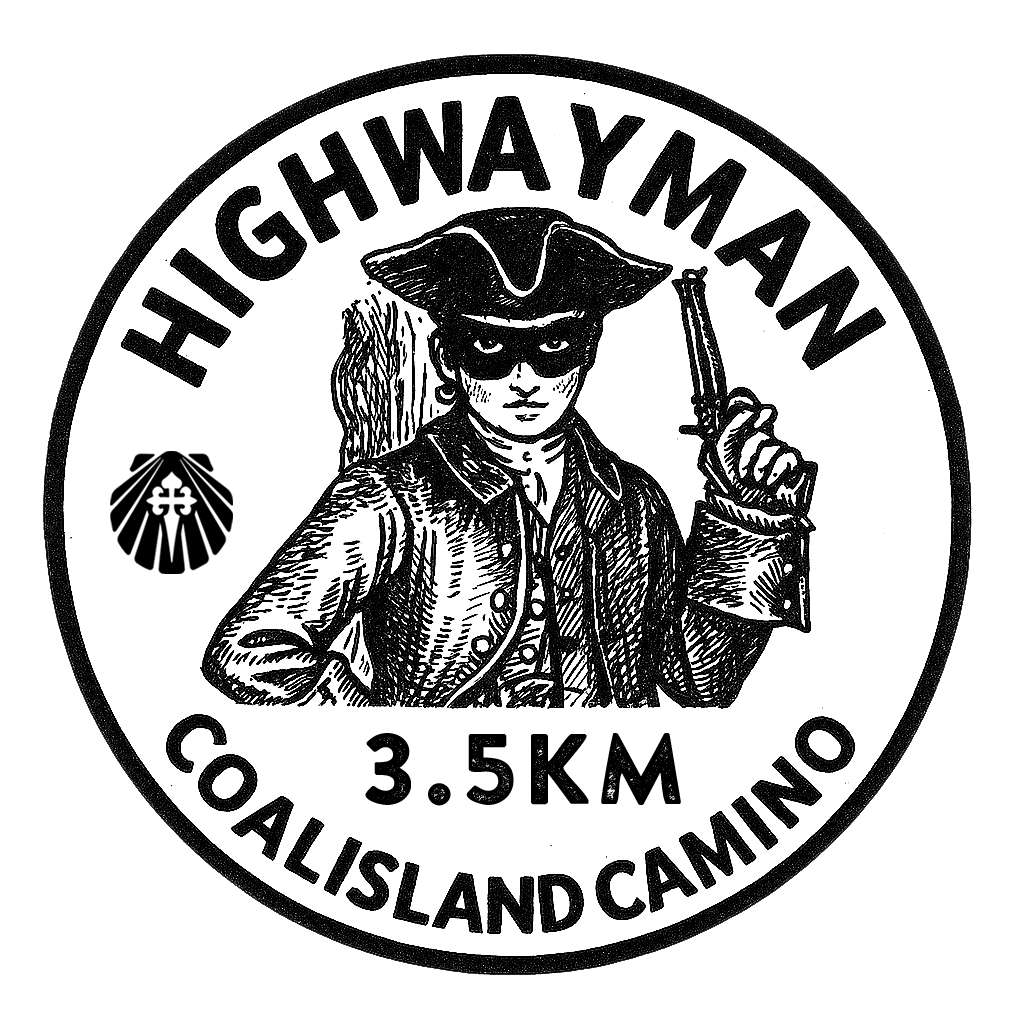
Highway Man
Local folklore recounts the exploits of a highwayman named Reilly, who operated along this route, now part of our Camino.
READ MORE
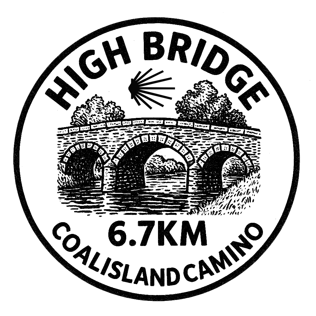
High Bridge
The old High Bridge has long since been replaced by a much flatter crossing than the old historic bridge over the canal.
READ MORE
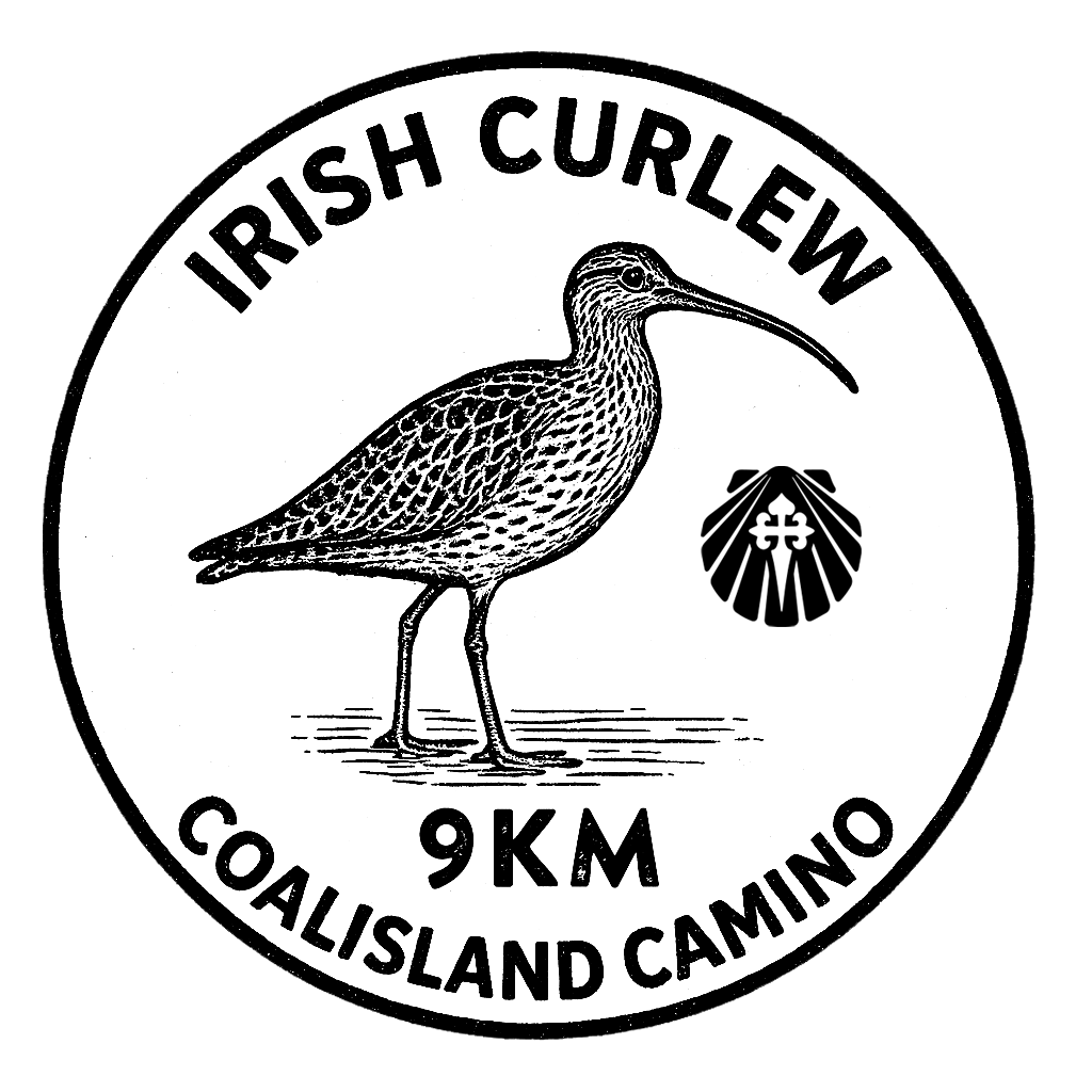
Irish Curlew
Have you ever heard the eerie, whistling call of the curlew across a quiet bog or meadow? If not, you might never get the chance.
READ MORE
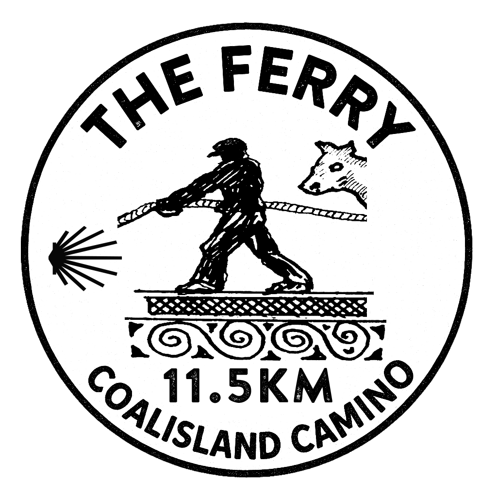
Maghery Ferry
Maghery was once a key point of transit and trade between Armagh and the south Tyrone area. An ancient road known as St. Patrick’s Trail is said to have passed through the area.
READ MORE
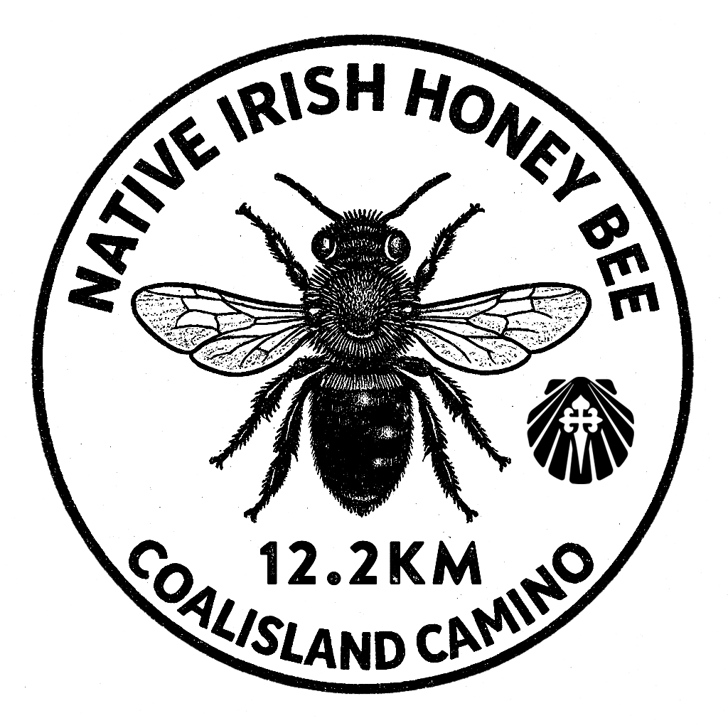
Native Irish Honeybee
Did you know Ireland has its very own native honeybee? The Native Irish Honeybee is a special type of dark honeybee that has lived in Ireland for thousands of years.
READ MORE
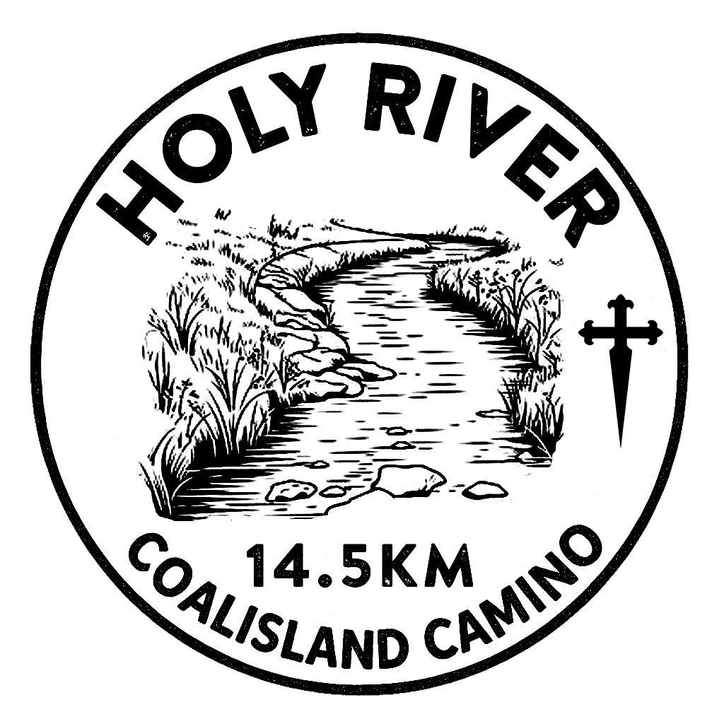
Holy River
Two fairs were held annually at Washingbay: on the Sundays immediately before and after Midsummer, the latter being called ‘Big Sunday.’ These events coincided with the Feast of St. John and included bathing in the Holy River.
READ MORE
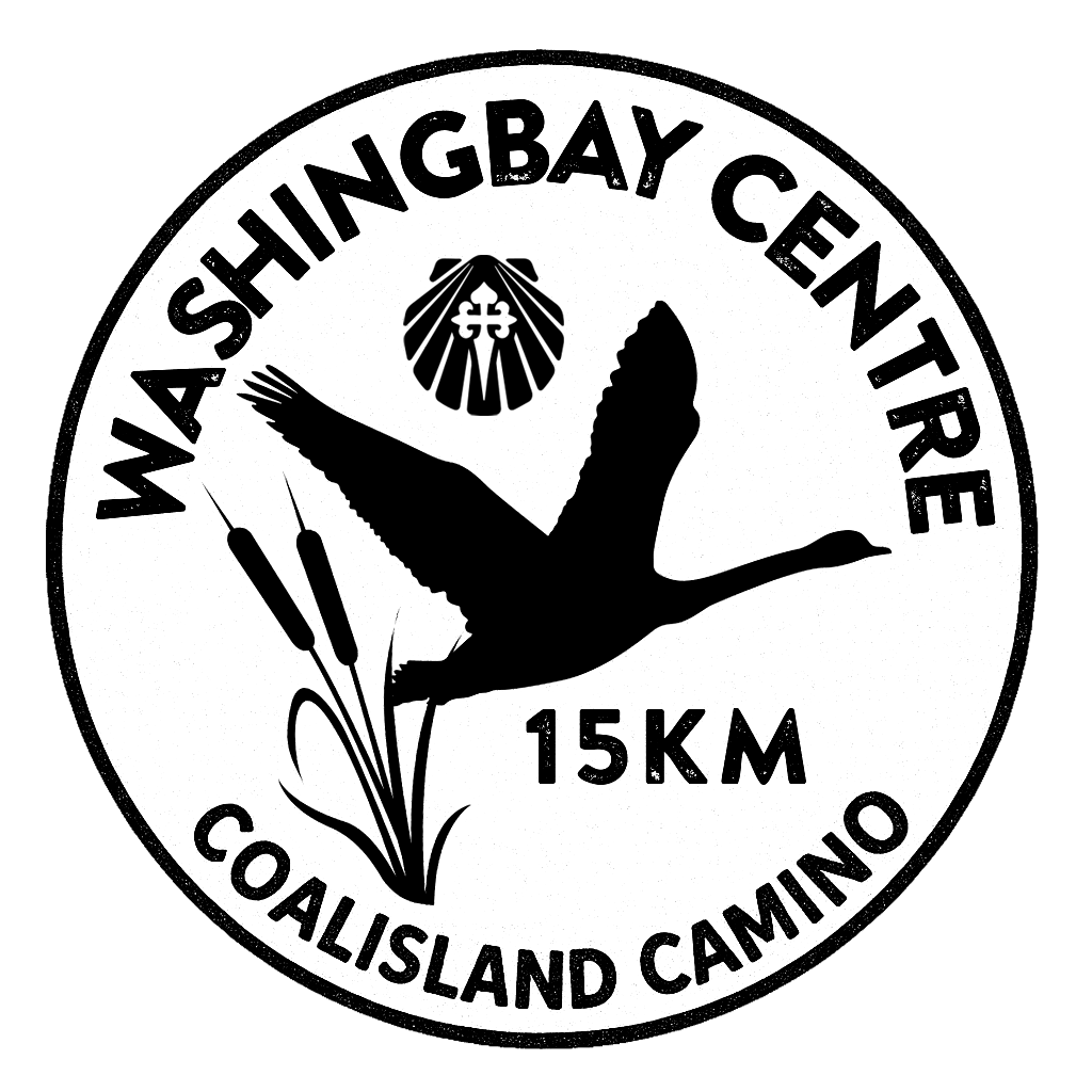
Washingbay Centre
The Washingbay Centre is owned and operated by Muintir na Mointeach – people of the boglands, a community-led development organisation based on the southwest shores of Lough Neagh, County Tyrone.
READ MORE
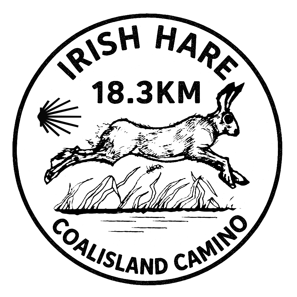
Irish Hare
The Irish hare is one of the oldest and most unique animals in Ireland, and it’s found nowhere else in the world!
READ MORE
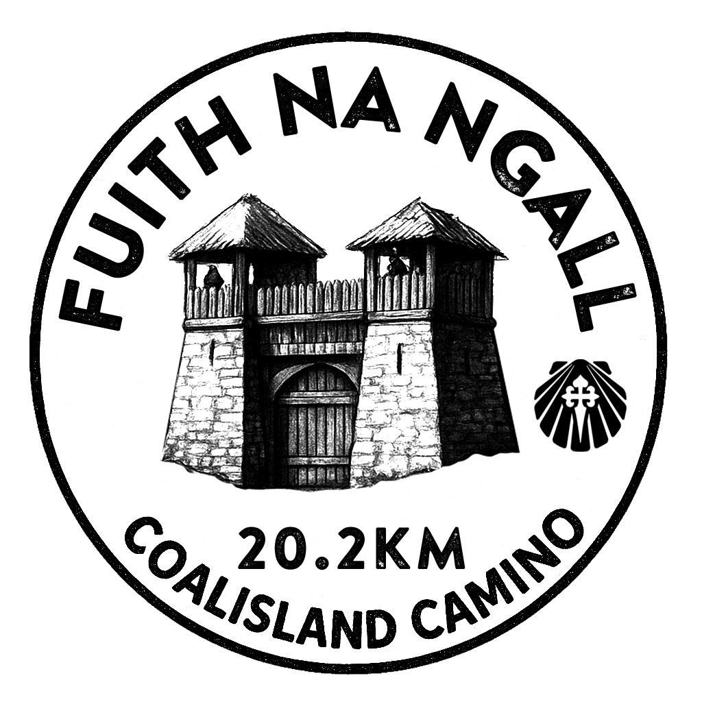
Fuith na Gall
Fuith na nGall, meaning “Abomination of the Stranger,” was a strategically significant fortress constructed by the Earl of Tyrone on the shores of Lough Neagh during the mid to late 16th century.
READ MORE
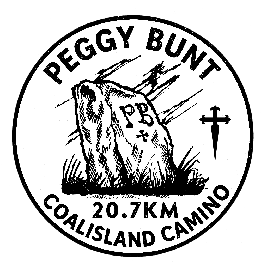
Peggy Bunt’s Grave
Local folklore tells the haunting story of a young woman known as Peggy Bunt and her fateful demise.
READ MORE
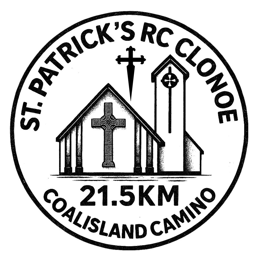
Clonoe RC Chapel
St. Patrick’s Church in Clonoe holds a deep historical and spiritual significance for the local community, serving as both a place of worship and a witness to pivotal moments in Irish history.
READ MORE
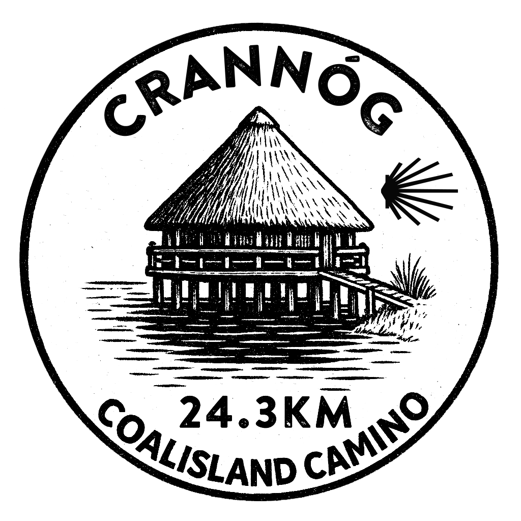
Irish Crannóg
An Irish crannóg is a man-made island dwelling, built in lakes or rivers for protection, dating back to ancient times, and East Tyrone has many examples.
READ MORE
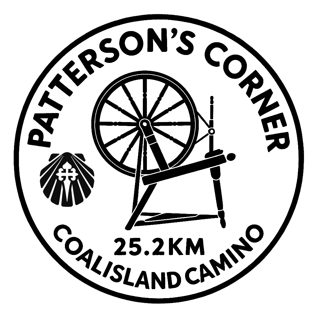
Patterson's Corner
Now the home of the Four Corners Bar in Brackaville, this iconic location in Coalisland’s industrial history could tell many stories.
READ MORE
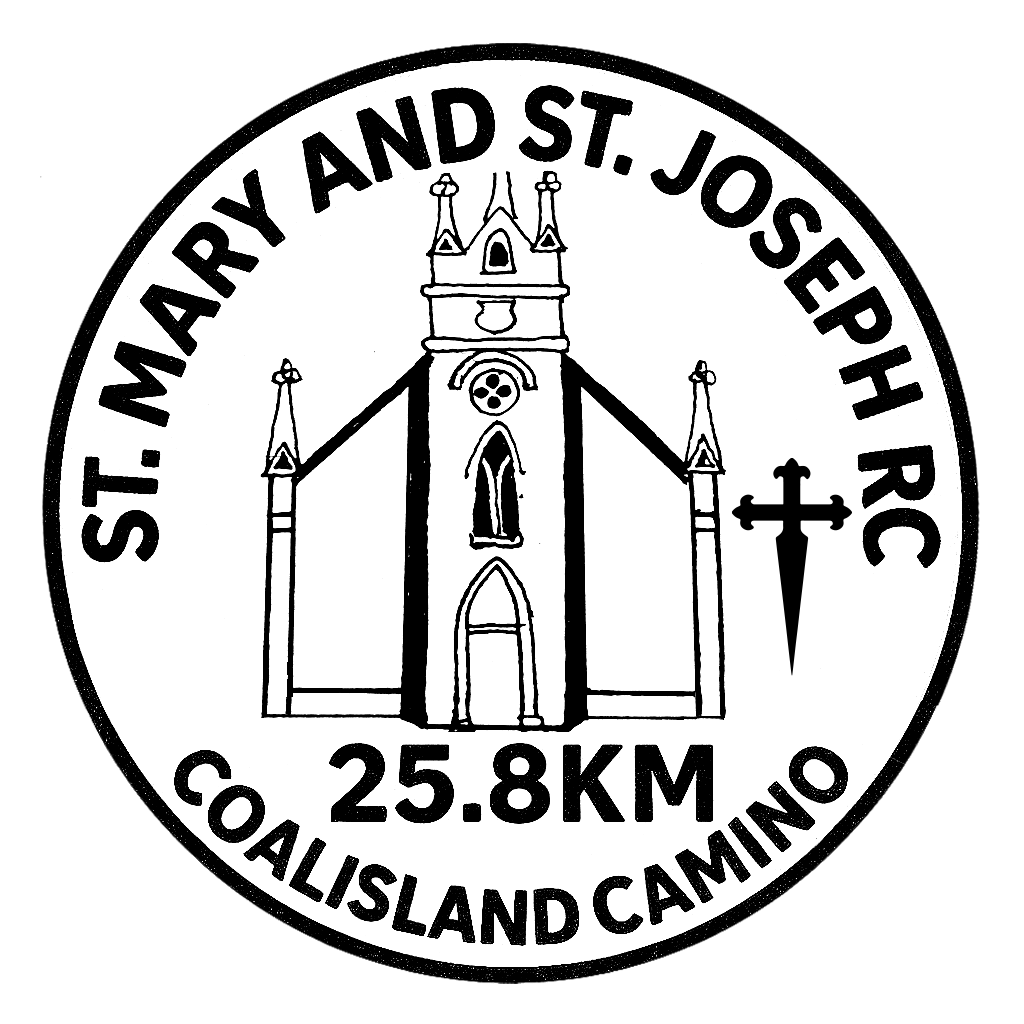
St Mary & St Joseph RC Church
St. Mary & St. Joseph’s Church stands as a central landmark in Coalisland’s religious and cultural life. Located in the parish of Ballyclog and Donaghenry, now officially known as Coalisland parish.
READ MORE
Let’s get walking
REGISTRATION
There are no shops along the route. Please bring your water and food.
Official Coalisland Camino Days:
We will provide free water along the route, and participants will be informed of the locations before their departure.
There will be several Portaloos along the route, and participants will be informed of these locations before their departure.
The Washingbay Centre (on route – 15 km) will be open 10 am – 3 pm on our Official Camino Walk days, and warm food and refreshments can be purchased.
There will be ample seating and toilet facilities available, and it is a welcome resting point for pilgrims. There is a Vivo shop and a Public house, both less than 1 km away, at 6 Reenaderry Rd, Coalisland BT71 5DT.
Walking the Coalisland Camino on your own time:
Our unique Coalisland Passport can be purchased, and we will provide details for the stamp locations before your Camino (see Personal Camino booking link).
The Camino is set in a very rural location. Public Services are very limited. We suggest you ensure you have adequate supplies before departing.
Herrons Shop, Barrack Street, Coalisland, BT71 4LS is just beside the Camino start.
Newell Stores, 11 Lineside, Coalisland, BT71 4LP, is 300m into your Camino, at the start of the Canal pathway. Toilet available.
Springisland Supermarket, 2 Washing Bay Rd, Coalisland, BT71 4ND is 350m into your Camino, opposite the start of the Canal pathway. Toilet available.
SPAR Clonoe, 52a Moor Rd, Coalisland, BT71 4QB, is less than 1km away from the Moor Road crossing. Toilet available.
The Washingbay Centre (on route – 15 km) has limited opening hours, and you should check these times before you commence your walk. Warm food and refreshments can be purchased, and toilet facilities are available, and it is a welcome resting point for pilgrims. www.washingbay.org
Vivo shop and a Public house, both less than 1 km from Washingbay Centre (not on route), at 6 Reenaderry Rd, Coalisland BT71 5DT. Toilet available.
St. Patrick’s RC Church, on the route at 21.5km, has toilet facilities. Limited opening.
Four Corners Bar (Pattersons Corner stamp) on the route has toilet facilities.
Please ensure you have informed someone of your Camino walk, and agree on a time for checking in, for your safety.
Please remember that you should leave no trace – please do not discard any litter.
Beggy Bunt
Local folklore tells the haunting story of a young woman known as Peggy Bunt. Her real name was reportedly Margaret Jane White, and she worked as a housemaid for a gentry family in the townland of Magheramulkenny. As was sadly not uncommon at the time, the local gentleman took advantage of Peggy. When it became apparent that she was pregnant, he is said to have murdered her to conceal his sordid actions.
To cover up the crime, the man claimed that Peggy had taken her own life by hanging. At that time, those who died by suicide were forbidden burial in consecrated ground. Instead, Peggy’s body was interred in a ditch this “three-road end”, adjacent to the estate. This type of junction, known as a “three-road end” or “corpse road,” was historically used as a burial place for those considered outcasts, suicides, criminals, witches, or the cursed.
Three-road ends and crossroads were believed to hold supernatural power, both protective and perilous. The belief was that spirits would become disoriented at such intersections, preventing them from returning to haunt the living. Instead, the soul was thought to remain bound to this place forever. The practice of burying individuals at crossroads was officially abolished in 1823.
Peggy Bunt’s grave was once marked with a stone, and local people kept the grass cut, and tidy, however, this marker was destroyed during roadworks in the early 1970s. Older locals recall walking past the site on their way to Mass in the 1950s as children, always running past the grave in fear that Peggy’s ghost might appear.
Irish Hare
The Irish hare is one of the oldest and most unique animals in Ireland, and it’s found nowhere else in the world! This wild and speedy mammal has lived on the island for thousands of years, even before the last Ice Age. Unlike rabbits, which were brought to Ireland by humans, Irish hares are truly native.
They are bigger than rabbits, with longer legs, shorter ears, and a reddish-brown coat that sometimes turns slightly white in winter. You might also spot the black tips on their ears if you’re lucky enough to see one in the wild.
Irish hares live in many different habitats, grasslands, bogs, coastal areas, and even mountain slopes. They don’t dig burrows like rabbits. Instead, they rest in shallow nests called “forms” hidden in the grass.
They are most active at dawn and dusk and can run in fast zigzags to escape predators like foxes or birds of prey. Sadly, like many wild animals, the Irish hare faces threats from habitat loss, farming, and hunting.
Changes to the countryside mean less space for hares to live, hide, and raise their young. Even so, they are still found all over Ireland, and conservation groups are working to make sure they stay that way.
The Irish hare is not just important for nature, it also appears in Irish legends and old stories. It’s a symbol of speed, mystery, and survival.
So next time you’re walking in the countryside, keep an eye out for a flash of reddish fur dashing through the grass. It just might be one of Ireland’s most iconic, and fastest, residents: the Irish hare!
Irish Curlew
Have you ever heard the eerie, whistling call of the curlew across a quiet bog or meadow? If not, you might never get the chance. The Irish curlew is one of Ireland’s most endangered birds, and it’s disappearing fast. The curlew is easy to spot with its long, down-curved beak, brown speckled feathers, and long legs.
It uses its beak to dig into soft ground for worms and insects. But it’s not just how it looks that makes it special, it’s the sound it makes. The curlew’s haunting call is one of the most famous bird sounds in Ireland, often described as sad and beautiful.
Just 40 years ago, there were around 5,000 curlew pairs nesting across the country. Now, fewer than 150 pairs remain in Ireland, with approximately 6 nesting pairs in this area. That’s a shocking drop. Why is this happening? Mainly because the curlew’s nesting places, bogs, grasslands, and wet meadows, are disappearing. Many have been drained or turned into farmland.
The birds also nest on the ground, making their eggs easy targets for predators like foxes and crows. But all hope is not lost. Wildlife groups and the Irish government are working hard to save the curlew. Special projects now protect nests, watch over chicks, and help farmers care for curlew-friendly land.
The curlew is more than just a bird, it’s a part of Ireland’s natural heritage. Saving it helps protect many other wild creatures and the special places they live in. So next time you’re out in the countryside, keep your ears open. That strange, beautiful whistle you hear might just be one of the last Irish curlews calling.
Native Irish Honeybee
Did you know Ireland has its very own native honeybee? The Native Irish Honeybee (Apis mellifera mellifera) is a special type of dark honeybee that has lived in Ireland for thousands of years. It’s perfectly adapted to our cool, damp climate and plays a crucial role in keeping our countryside alive and buzzing!
These bees are smaller and darker than the ones you might see in other countries. They are known for being hardy, meaning they can survive colder weather better than many other bee types. They’re also excellent at collecting nectar and making honey even when the weather isn’t perfect.
One of the most important jobs of the Native Irish Honeybee is pollination. As they fly from flower to flower collecting nectar, bees help plants grow, breed, and produce food. Without bees, many of our fruits, vegetables, and wildflowers simply wouldn’t exist.
Each hive can contain up to 50,000 bees during the summer months. Honey from native Irish bees often has a richer, darker flavour thanks to local flowers like clover and heather. Unfortunately, this native bee is under threat.
Imported bee species, diseases, habitat loss, and pesticides have all made life harder for our local bees. Some beekeepers and scientists are worried that the
Native Irish Honeybee could disappear if we’re not careful. But there’s good news: people across Ireland are working to protect them! Beekeepers are raising awareness, planting more wildflowers, and encouraging people to avoid harmful chemicals in gardens and farms. There are even laws being discussed to ban the import of non-native bees.
The Coalisland Camino passes the local Low Country Native Irish Honey Bee Association, or “Bogbees” as they are better known, and this dedicated group of beekeepers is at the forefront of conserving our native Irish Black Honey Bee, and has established a Native Irish Honey Bee ‘bee corridor’ along the south-west banks of Lough Neagh from the Blackwater River at Maghery Ferry to the Lower Bann River at Toome.
By protecting our native bees, we’re also protecting the future of Irish food, flowers, and biodiversity. So next time you see a bee buzzing by, remember, it might just be a tiny, hard-working hero helping to keep Ireland blooming!
Crieve Lough Crannog, Stewartstown
Crieve Lough, near Stewartstown in County Tyrone, is a landscape steeped in layered history, revealing traces of settlement from the Bronze Age through the early modern period. Along its shores are the remains of ancient ringforts, offering evidence of early habitation and community life.
At the centre of the lough lies a crannog, a small, man-made island associated with one of the most dramatic episodes in Irish history. Hugh O’Neill, the last great Gaelic lord of Ulster, spent his final night in Tyrone on this crannog before embarking on the Flight of the Earls in 1607.
His departure symbolised the collapse of Gaelic power in Ireland and the beginning of a new colonial order.
Roughan Lough Crannog, County Tyrone
Roughan Lough, located near Newmills, Coalisland, and Stewartstown in County Tyrone, is home to a small crannog, an ancient, man-made island. Overlooking the lough is Roughan Castle, a 17th-century fortified residence constructed during the Plantation of Ulster, offering a striking reminder of the area’s colonial past.
The crannog, visible to the north-east of the lough, was once described as “O’Neill’s strongest island fort” at the beginning of the 17th century. It served as a strategic refuge during times of political unrest, most notably during the aftermath of the 1641 Rebellion.
Sir Phelim O’Neill, a leading figure in the uprising against English rule, sought sanctuary on the island in 1653. However, he was eventually discovered, captured, and taken to Dublin, where he was executed for treason.
Mac’s Lock: Where Industry Meets Local Legend
Mac’s Lock is one of the most iconic points along the Coalisland Canal, also known historically as the Tyrone Navigation. Built in the 18th century, the canal was designed to carry coal from the Coalisland coalfields to Belfast & Dublin, connecting the heart of rural Tyrone with the expanding industrial centres of Ulster.
The lock helped boats manage changing water levels, making the four-mile journey toward Lough Neagh and beyond possible.
This quiet stretch of water once bustled with barge traffic and local activity.
Locks like this were engineering achievements, but they were also social spaces, places where work, conversation, and community life came together.
Tom Fox and the Greyhound That Almost Made History:
1950s Clonoe & Tyrone GAA footballer Tom Fox lived beside Mac’s Lock. Known for his skill on the pitch, Tom later gained fame in another arena, as a greyhound trainer. One of his dogs, named Macs Lock after this very place, came within a short head of winning the 1989 Irish Greyhound Derby, the most prestigious race in the sport.
Today, the old overgrown lock can be seen on the left-hand side, just as you cross the Gortgonis Road. Mac’s Lock is a peaceful reminder of the area’s rich industrial and sporting heritage. It tells a story not just of coal and canals, but of people, pride, and the lasting bond between place and identity.
Patterson’s Corner: The Roan Mill Lockout of 1917
In 1917, a major labour dispute erupted at Roan Spinning Mills, Coalisland, threatening the future of one of the area’s most important employers. Though the mill was increasingly profitable, wages remained low, well below industry standards, and relations between workers and management had deteriorated.
A common grievance was the partial payment of wages in tokens, redeemable only at the company-owned mill shop. This widespread practice ensured profit for the owners but restricted workers’ freedom to spend their earnings. Tensions came to a head in early May when Henry Wilson, the mill’s owner, offered a modest wage increase, three shillings for men, two for women.
Workers rejected the proposal, demanding four shillings for men to bring wages in line with other mills. In response, 21 men were ‘locked out’ and denied access to the mill unless they accepted the terms. Matters escalated on 17 May when some girls in the reeling room were laid off. Their colleagues refused to work in protest, prompting management to lock out all 300 employees.
With no social welfare system, the owners believed workers would eventually return out of necessity. Instead, the community rallied behind them. A mass meeting held on 30 May in Coalisland drew over 400 people. A parade of women workers led a march from the mill into town, and the crowd unanimously passed a motion pledging full support for the strike.
Local businesses, including Robert Patterson, who owned a pub and grocery at what became known as Patterson’s Corner, offered food and aid. Roan Mills remained silent throughout the summer. Eventually, Wilson agreed to arbitration, persuaded by Patterson and Reverend Quinn, the local parish priest.
Workers returned in early November, victorious: Wilson granted a raise of five shillings for men and three for women, more than they had originally demanded.
St. Mary & St. Joseph’s Roman Catholic Church, Coalisland
St. Mary & St. Joseph’s Church stands as a central landmark in Coalisland’s religious and cultural life. Located in the parish of Ballyclog and Donaghenry, now officially known as Coalisland parish, this church has served generations of worshippers and reflects centuries of Christian heritage in East Tyrone.
The earliest records of Ballyclog and Donaghenry date to around 900 A.D., with references to these ancient parishes found in early ecclesiastical documents. These texts also bear witness to the missionary work of St. Patrick, who is believed to have preached in the region some 450 years earlier, leaving a lasting imprint on the spiritual landscape.
Originally known as Stewartstown parish from 1822 until 1854, the area was renamed Coalisland parish following boundary changes. By the mid-19th century, the Catholic population of Coalisland was growing rapidly, in contrast to the declining population in Stewartstown. Responding to this shift, Fr. Peter Daly, appointed parish priest in 1853, undertook the ambitious task of building a new church in Coalisland at the graveyard site in Brackaville.
Construction proved challenging due to the widespread poverty following the Great Famine and limited financial support. Despite these difficulties, Fr. Daly’s determination prevailed, and the new church was completed and consecrated in 1862. It has served the community ever since.
St. Mary & St. Joseph’s is believed to have been designed by John O’Neill, a noted architect. His architectural vision helped shape the aesthetic and spiritual character of Catholic churches in the region during a time of renewal and resilience.
Today, St. Mary & St. Joseph’s continues to embody the enduring faith, perseverance, and identity of the Coalisland community.
Maghery Ferry
Maghery (from the Irish an Machaire, meaning “the plain”) is a small village and townland located on the southwestern shore of Lough Neagh, near Derrywarragh Island in County Armagh. The name is a shortened form of Magherygreenan (Machaire Grianáin), reflecting its long and storied Gaelic heritage. Strategically positioned between the estuaries of the Rivers Blackwater and Bann, only two miles apart, Maghery was once a key point of transit and trade between Armagh and south Tyrone.
An ancient road known as St. Patrick’s Trail is said to have passed through the area, linking Armagh to Coney Island via a series of causeways. Sections of this route have been identified in nearby townlands, including Derrylileagh.
In 1835, the Ordnance Survey Memoirs described Maghery as a modest fishing village with sixteen one-storey thatched houses scattered near the Lough Neagh shoreline. Fishing remained a key livelihood for many local families well into the 20th century. Just offshore lies Coney Island, a site of continuous human settlement from the Mesolithic period through to the Iron Age.
The island, once known as Innisclabhall and later Sydney’s Island, was part of the Charlemont Estate until 1946, when it was entrusted to the National Trust. Notably, Coney Island is often cited as the namesake for its more famous counterpart in New York. Archaeological features include an Anglo-Norman motte, a circular 16th-century tower, and early defensive structures.
Nearby on Derrywarragh Island, the remains of a 17th-century fortified house, known locally as O’Connor’s Stronghold, stand as a relic of early modern military architecture.
The structure likely served as a watchtower to guard the entrance to the River Blackwater, highlighting the area’s strategic importance through centuries of settlement and conflict.
The Rapparee / Highwayman:
The former residence of the McGrath family, situated atop Annaghmore Hill to the north, once served as a coach stop along what was historically referred to as the Dublin coach road. From this elevated location, the road descended toward a ford on the Torrent River, predating the construction of the canal, near the present-day residence of the Lynch family in the townland of Corr. The road continued onward to Charlemont Fort, a strategically significant site during the period. Local folklore recounts the exploits of a highwayman named Reilly, who operated along this route and is reputed to have concealed stolen gold both along the road and on the banks of the Torrent River.
During this historical period in Ireland, highwaymen were often referred to as rapparees or tories. The term rapparee originally described dispossessed native Irish foot soldiers who engaged in guerrilla resistance against English forces, particularly during the Irish Confederate Wars (1642–1651) and later, during and following the Jacobite War (1689–1691). The name derives from their weapon of choice, the rápaire, a shortened version of the standard military pike, typically measuring approximately six feet (2 meters) in length, as opposed to the regulation sixteen feet (5 meters).
Alternatively, these figures were known as Tóraí or Tóraidhe in Irish, meaning “pursuer” or “seeker,” terms that later took on the connotation of bandit, robber, or outlaw. Many rapparees were former members of the Gaelic nobility who maintained the traditional code of conduct of Irish clan chieftains. Prominent examples include Seán Bearna Ó Donnghaile of Cappagh (East Tyrone), Redmond O’Hanlon of Tandragee (Mid Armagh), Michael “Galloping” Hogan of East Limerick, Éamann an Chnoic Ó Riain of Mid Tipperary, and Séamus Mór Mac Murchaidh of South Armagh. The latter two are credited with guiding Patrick Sarsfield’s cavalry in the successful destruction of the Williamite siege train at the Siege of Limerick in 1690. After the wars, many former guerrillas turned to banditry, solidifying the association between rapparees and highwaymen in Irish historical memory.
St. Patrick’s RC Church, Clonoe
St. Patrick’s Church in Clonoe holds a deep historical and spiritual significance for the local community, serving as both a place of worship and a witness to pivotal moments in Irish history. The original St. Patrick’s Church was built around 1780, standing for over 200 years in the graveyard opposite the current church site. A symbol of enduring faith, it withstood considerable trials.
In 1798, the church was wrecked during the Irish Rebellion, and again in 1829, it came under sectarian attack during the Black Bridge Fight. During this assault on 13th July 1829, three local men, brothers, John & Hugh O’Neill, and John Ritchie lost their lives defending the church. Their sacrifice is remembered and recorded in the adjoining cemetery.
The church was restored around 1830 under Fr. Bernard Weaney, and again in 1932 by Fr. James Clark, P.P. Its design was cruciform, a cross-shaped layout, that would inspire the architectural vision of the future church. As the needs of the parish evolved, a new church was constructed under the leadership of Fr. Kieran McKeown, P.P. He intentionally mirrored the cross-shaped design of the old church, preserving a physical and symbolic link with the past. He also ensured that many sacred artefacts from the original church were carefully incorporated into the new building, including: The altar, Stained glass windows, The Stations of the Cross, Statues, Holy water fonts, The bell, The sanctuary lamp.
The final Mass in the old church was celebrated on Sunday, 29th November 1987, and the first Mass in the new church took place that same evening, marking a seamless transition from the past to the future.
Tragically, the new church, too, would witness the violence of its time. On 16th February 1992, it was damaged during a British Army (SAS) ambush on an IRA unit near the church grounds. The ambush followed an attack on the RUC station in Coalisland, and resulted in the deaths of four young local men, Sean O’Farrell, Barry O’Donnell, Peter Clancy and Patrick Vincent, all young men in their early twenties. The incident, widely regarded as a controversial use of lethal force, left a lasting mark on the community.
The loss of life and the damage to the church underscored the deep impact of the Troubles on even the most sacred and peaceful of places, with incidents spanning almost 200 years. St. Patrick’s Church, Clonoe stands today not only as a house of worship but as a testament to the resilience, sacrifice, and unity of its parishioners throughout centuries of struggle and change.
It remains a cornerstone of spiritual life and historical memory in the community.
The High Bridge
The old High Bridge has long since been replaced by a much more flat crossing. “Civil” Jack O’Neill lived beside the High Bridge and it is said he earned his nickname by coming to the aid of drivers who had trouble getting their horse and carts over the height of the bridge.
The final 7th lock on the canal or the 1st lock if you were entering from the River Blackwater is situated close to the High Bridge opposite the two century old lockhouse and 500 metres from the bank of the River Blackwater.
The Point is further down from the High Bridge and it’s where the Canal/River Torrent meets the River Blackwater at a point 4km West of Lough Neagh. The Torrent River rises at Black Hill 10km North West of Dungannon and is one of the three legendary ‘black rivers of Ireland’ which are said to have burst forth in prehistoric times.
The Navvies graveyard is down past the lockhouse in Derryavena (pronounced –“Dravna”) and may also have been used as a Cillín (a burial ground for unbaptised infants). The Navvies were the labourers who built the canal.
The “proccy” hole is a field close to the High Bridge where the puddling clay was made. This is the clay that was used to seal the bottom and sides of the canal.
Coalisland Cornmill
The Coalisland Cornmill, also known as Stewart’s Mill, is a significant industrial and architectural landmark that has stood at the heart of Coalisland for over a century. Constructed in 1911 within the Canal Basin and operated by the Lagan Navigation Company, the mill marked a major expansion for Robert Stewart and Sons, who had previously operated a flour mill along the Dungannon Road.
The new facility was designed by architect Thomas Henry and represented a modern, purpose-built structure for grain processing. The mill’s strategic location beside the Coalisland Canal enabled efficient transportation of milled corn to national markets.
The canal served as a vital trade route, allowing bulk goods to be shipped affordably and reliably. However, the rise of motorised transport in the 1930s led to a gradual decline in canal traffic.
By 1954, the canal was officially abandoned, with road haulage emerging as the dominant mode of grain transportation. Despite its logistical advantages and industrial scale, the Cornmill eventually succumbed to economic pressures.
Increased competition from larger mills in Belfast and the availability of cheaper imported grain significantly reduced its competitiveness. Though milling operations had begun as early as 1907, the facility continued to function, performing the daily functions of storage, milling, and packaging the final product of processed corn until its closure in 1978.
After lying dormant for over a decade, the Cornmill underwent significant restoration and was officially reopened in 1993 by President Mary Robinson.
Today, it stands as a preserved symbol of Coalisland’s industrial heritage, reflecting both the town’s historical reliance on canal-based trade and the broader economic transitions of the 20th century.
Coalisland & its canal
Coal mining in East Tyrone was first reported in 1654. Coalisland emerged as a result of the Industrial Revolution in Ireland. It had potteries, brickworks, textile mills, weaving factories, and coal mines.
The town of Coalisland developed around the terminus of the Coalisland Canal, which was originally intended to transport coal from the Tyrone coalfields to Dublin. Without the coal mines, the town of Coalisland would not exist.
The town takes its name from two parts of its historic past – “COAL” is linked to the mines and “ISLAND” is linked to the canal and the harbour, or Basin, which was built in the centre of the town.
Construction of the canal began in 1733 but wasn’t completed until 1787 due to delays. Linking the coalfields to Lough Neagh via the River Blackwater, the canal struggled in its early years and came close to being abandoned.
However, the trade of agricultural goods and the import of farm and mining equipment sustained its use. In the 19th century, a major restoration effort, dredging, rebuilding locks, and improving towpaths, revitalized the waterway. This transformed the old route into a functioning canal, helping Coalisland evolve into a unique inland port.
Although traffic increased, it never reached the expected levels. Still, the canal became a central trade hub for nearby villages and towns, encouraging the growth of local industries. Horse-drawn lighters carried goods to Belfast in three days and to Newry in two, though low tolls meant the canal barely broke even. By the late 1800s, trade improved, but railways began to threaten the canal’s relevance. Despite growing exports like fireclay, sand, bricks, and pottery, and imports such as groceries and grain, rail and motor transport offered faster delivery.
By the 1930s, local merchants began shifting to lorries, though some businesses like John Stephenson and Son Ltd continued using the canal. World War II further weakened the canal’s use. Lighters were requisitioned for military use, and trade diminished.
Even though it passed inspection in 1943, the Stormont government had already decided to shut it down. The last commercial lighter sailed in 1946. In 1954, the Coalisland Canal was officially abandoned, and downgraded to a drainage ditch.
The Basin was filled in by 1961, and one of the last lighters, Eliza, was buried beneath what is now the Coalisland Heritage Centre’s car park, once the site of Stewart’s Mill. 1970 brought the closure of North’s last working coalmine at Coalisland.
The first colour film ever to be processed in BBC Belfast and transmitted in full colour to north of Ireland viewers was about the closure of the very last coalmine in the province.
Ironic really, can you think of anything more black and white than a coalmine?
Fuith na nGall Fort
Fuith na nGall, meaning “Abomination of the Stranger,” was a strategically significant fortress constructed by the Earl of Tyrone on the shores of Lough Neagh during the mid to late 16th century (c. 1553–1585).
Believed to have been positioned atop Cloghog Hill, the fort offered a commanding view over Lough Neagh, strategically located between the deep-water bays of Brocagh (Mountjoy) and the River Blackwater (within the townlands of Derryloughan and Maghery), and also over the main thoroughfare between east Tyrone/Derry, and Armagh/Dublin.
Despite its fortifications, Fuith na nGall was soon captured and destroyed by English forces. Today, only remnants of its original earthen walls remain, with its defensive moat filled in during the 1970s by a subsequent landowner unaware of its historical value. According to local tradition, the fort’s construction was financed in part by Spanish gold, intended to strengthen Irish resistance, preserve the Roman Catholic faith, and slow English expansion eastward.
Nearby Mountjoy Castle further reflects the intense military and political contestation of the era. Built in 1601 by the Earl of Mountjoy, then Lord Deputy of Ireland, the castle served as a counter to the Earl of Tyrone’s influence.
Constructed from locally produced brick and situated on an elevation overlooking Lough Neagh, Mountjoy Castle played a key role during the Ulster Plantation. King James I recognized its importance by incorporating the surrounding area into a borough and allocating 600 acres, half for civic support, half for maintaining a garrison.
The castle was seized during the 1641 uprising by Turlough O’Neill and held until its recapture by General Monroe in 1643. It was dismantled by parliamentary order in 1648 and has since remained in ruins. St. Michael’s Old Church in Clonoe (close to Fuith na nGall), founded in 1431, also stands as a monument to the region’s layered religious and cultural history.
The church and its graveyard, containing the remains of both native Irish families, such as the O’Neills, and settler English families, reflect the complex heritage of the area. Notably, Major Hugh Mergaugh O’Neill, who died in 1671, is interred here, underscoring the site’s enduring ties to the influential O’Neill dynasty.
St. Patrick’s Hall
Constructed in 1888, St. Patrick’s Hall has long served as a central hub for the political, cultural, and communal life of Coalisland, County Tyrone. The structure originally comprised a main hall, an underground cellar, and adjoining upper and lower rooms, facilitating a wide range of local activities.
In the early 20th century, the hall was home to a billiards team and played a key role in the Gaelic Revival. Notably, in 1904, the founding meeting of Coalisland Fianna took place in the cellar, reportedly “by the light of a candle”, and was attended by many individuals aligned with the cultural nationalist movement of the time.
Throughout the 20th century, St. Patrick’s Hall remained a focal point for political discourse and community organisation. It hosted a variety of events central to local life, including dances, feiseanna, musical performances, plays, bingo, bazaars, youth clubs, and activities promoting Irish language and culture. For generations, it functioned as the epicentre of Coalisland’s engagement with national heritage and community cohesion.
However, by the early 2000s, the hall had fallen into a state of disrepair. In a twist of fate, the COVID-19 pandemic in 2020 provided an unexpected opportunity for renewal.
The parish offered the hall as a base for the Covid Emergency Response Group, which later evolved into the Coalisland Community Hub & Foodbank.
Volunteers initiated repairs to stabilise the structure, and with the support of community funding, the entire building was refurbished.
Today, St. Patrick’s Hall has reclaimed its role at the heart of the community. Under the stewardship of the Community Hub, it now hosts a range of services and programmes including a foodbank, health and wellbeing initiatives, educational courses, and creative workshops.
It is also home to Friends2Talk, a mental health support group, and creators of the Coalisland Camino, further affirming the hall’s enduring legacy as a space for connection, support, and cultural continuity.
St. Patrick’s Hall
St. Patrick’s Hall in Coalisland, occupies a unique place in the history of the Irish revolutionary period. In the days preceding the 1916 Easter Rising, it became the staging ground for what has been termed “the Ulster Rising that never was.”
Led by Dennis McCullough, President of the Irish Republican Brotherhood, a contingent of 156 Belfast Volunteers gathered in Coalisland, intending to join forces with the Tyrone Volunteers and proceed to Galway to support a wider insurrection in the West of Ireland.
According to later accounts from Belfast Volunteer Peter Burns, the group was armed with 42 rifles of various types, and most carried personal sidearms. Burns recalled James Connolly’s directive to the Ulster Volunteers: “You will fire no shot in Ulster; you will proceed at all possible speed to join Mellows in Connaught… If we win through, we can deal with Ulster.” Burns also credited members of Cumann na mBan, particularly Nora and Ina Connolly, Winifred Carney, Bridie Farrell, Lizzie Allen, Kathleen Murphy, Elizabeth and Nell Corr, and a local woman named O’Neill, for their mobilisation and active participation, including some who went on to take part in the Dublin Rising.
Another volunteer, Cahal McDowell, recounted a direct warning from Patrick Pearse that only the instructions issued by the Military Council were to be followed during mobilisation. Volunteers were quartered in three separate groups around Coalisland, with a high level of operational awareness; they not only knew they were under Royal Irish Constabulary surveillance, but had identified two constables by name, Hanrahan and Kelly.
Despite these preparations, two local Priests intervened, urging the volunteers to heed Eoin MacNeill’s countermanding order, which advised against rising.
Many local volunteers, while willing to fight, expressed a preference for action in their own area rather than marching to Connacht. Ultimately, under instruction, the assembled volunteers dispersed on Easter Sunday, unaware of the historic events already unfolding in Dublin.
After meeting Padraig Pearse, Nora Connolly O’Brien returned to Coalisland with fresh orders for the Irish Volunteers to take part in the Rising, but alas it was too late. In 1966, on the 50th anniversary of the Rising, Nora Connolly (daughter of James Connolly), with local people who were actively involved in the events of 1916, helped unveil the anniversary Plaque on St. Patrick’s Hall which reads “to commemorate the assembly of Irish Volunteers in this hall Easter 1916, prepared to give their lives for Irish freedom”.
The Holy River at Washingbay
The curative properties of the waters at Washingbay on Lough Neagh have been recognized since at least the seventeenth century. A significant early reference appears in a letter dated 12 February 1712, from Francis Nevil, Esquire, to the Lord Bishop of Clogher, recorded in the Ordnance Survey Memoirs of County Tyrone.
In the letter, Nevil recounts a case involving Mr. Cunningham’s son, who suffered from a severe affliction described as “the evil,” manifesting in multiple open sores that left him unable to walk. With conventional remedies proving ineffective, the boy was brought to the shore of the lough, where he was bathed daily. Remarkably, within eight days, the sores healed entirely.
He later married, had children, and lived for another decade. Nevil notes that the area, referred to as ‘Fishingbay,’ was also known as Washingbay, a site where people gathered on Midsummer Eve to bathe themselves and their livestock, seeking cures. The practice was integrated into local religious and social traditions.
Two fairs were held annually at Washingbay: on the Sundays immediately before and after Midsummer, the latter being called ‘Big Sunday.’ These events coincided with the Feast of St. John and included bathing in the Holy River, a small stream that flowed into the bay.
It was believed that these ablutions possessed healing powers, though some commentators suggested that similar cures might occur at any other point along the lough’s shores. While spiritual purification was the stated purpose, the fairs were equally noted for festivity, including music, dance, and drinking.
The Holy River Spa is marked on a 1788 map as a pool near the river’s entry into the lough. Oral tradition attributes its blessing to St. Brigid, said to have paused there enroute from Kildare to Ardboe.
Pilgrimage activity is evidenced by the discovery of devotional items such as coins, medals, and rosaries in the surrounding soil. The ritual of bathing, often involving red flannel rags tied to riverside trees, continued into the twentieth century, attracting pilgrims from distant counties like Galway and Mayo.
Local folklore also reports fairy activity in Roskeen and at the Hollies. A notable tale tells of the fairy king forewarning of a battle at Glenarm, with the turning of a local well to blood red as a sign of their permanent departure.
Phantom coach sightings along the former Dublin–Coleraine route further underscore the area’s rich supernatural heritage.
The Washingbay Centre
The Washingbay Centre is owned and operated by Muintir na Mointeach – people of the boglands, a community-led development organisation based on the southwest shores of Lough Neagh, County Tyrone.
Established in 2000, the group has been at the forefront of local development, environmental stewardship, and cultural preservation.
It manages the Washingbay Healthy Living Centre, situated within the scenic Wetlands Park, home to the first Local Nature Reserve established around Lough Neagh. Muintir na Mointeach serves the Washingbay area and the broader townlands of Derryloughan, Aughamullan, and Coole.
Derryloughan itself comprises seven sub-townlands, each beginning with “Derry”, reflecting their origins as clay islands amidst an extensive low-lying Sphagnum peat bog. This landscape, now ecologically significant, was once covered in native oak forest over 300 years ago.
Within a short distance of the Centre are several remarkable heritage sites: a Viking settlement, a crannog, a Bronze Age fort site, and a section of the ancient Pilgrim Path that once led from Donegal through the Sperrin Mountains, passing the historically significant Tulach Óg and onward along the shores of Lough Neagh to the ecclesiastical city of Armagh, and beyond.
The local community maintains a strong sense of identity, rooted in a long history of subsistence living, resourcefulness, and deep connections to both land and water. Over time, this evolved through periods of farming, peat extraction, and fishing, into a modern recognition of the area’s unique environmental and cultural value.
Today, Muintir na Mointeach supports a dynamic programme of activities and services through the Washingbay Centre, catering to all ages and interests, including Historical and cultural initiatives: People and Places Historical Group, Men’s Reminiscence Group, Storytelling events, Health and wellness: Walking Club, Pilates, Running Club, Mental Health Workshops, Recreation and sports: Kayaking Club, Bowling, Gaelic Games, Jujitsu, Chess, Arts and education: Irish Dancing, Music and Art Classes, Parent and Toddler Groups, Children’s Activities.
The Centre operates with a strong eco-friendly ethos, incorporating renewable energy technologies including a solar panel array, reed bed water filtration system, and wind turbine. It also hosts environmental and regeneration projects, providing a base for schools, clubs, and visiting groups to explore and learn about the local ecosystem.
The Washingbay Centre is available for private events, and continues to evolve as a social hub and a welcoming space for both locals and visitors. A recent highlight is the development of a 1-kilometre, disability-friendly walkway, created in partnership with the local Caoimhín De Barra GAA Club.
This accessible pathway has significantly enhanced the area’s appeal, attracting over 50,000 visitors annually and earning recognition as a model of rural community collaboration and shared purpose, and is a part of your Coalisland Camino. “Fáilte mhór roimh gach duine”